In this post, I go on an urban OSINT adventure and take on Bellingcat’s “Urban Exploration” challenges: Name That Street!, What A Dump!, Highway To The Unknown, Foul Play, and On The Metro.
Just like in my previous write-up on the Maritime Mysteries, I will walk through how I approached each task, what helped, what did not, and how I eventually arrived at the solution. Same as last time, I’ve made a video of me playing the challenge if you’d like to check it out.
Name That Street! – Time to explore the city
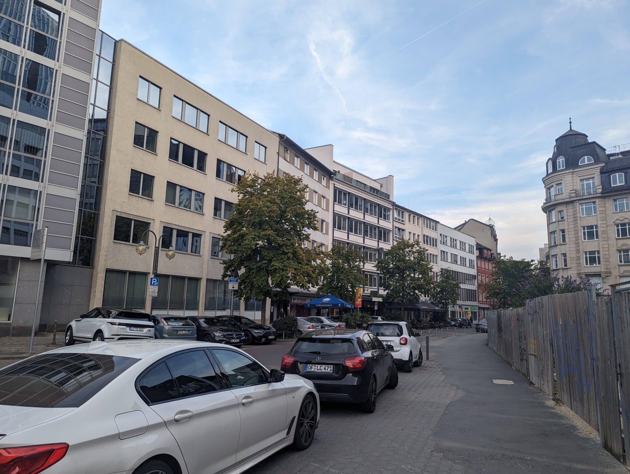
At first glance, this felt like a nice warm-up. The image showed a pedestrian street with some shops, cars, and just enough details to work with.
The first thing that caught my eye was the license plate. There was a “D” on the left, which stands for Deutschland, and the plate design fit EU plates. That was enough for me to lock in Germany as the likely country.
Next, I zoomed in on the visible signs. Some of the words were clearly in German, which reinforced the initial guess. One of the more distinctive storefronts was a shisha bar. I could make out part of the name saying “SHISHAND”, so I tried to search for it in Google Street View and quickly found a match pointing toward Frankfurt.
From there, it was all about confirming the surroundings:
Same style of buildings and roofline
Same fenced area and tower structure above the shops
Same store names, even though the design had changed
Everything lined up almost perfectly. After that, all I had to do was copy the street name.
Correct answer – Stiftstraße
What A Dump! – Looking for treasure?
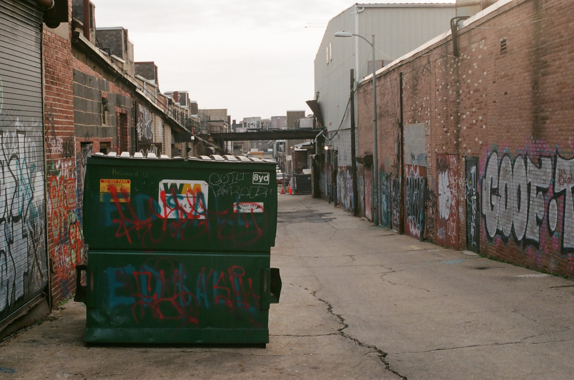
Compared to the first one, this challenge felt much more open-ended. The image showed a big green dumpster in a narrow alley full of graffiti. No obvious landmarks, no skyline, nothing that screamed a specific city. So I focused on the dumpster itself.
On the side of the bin, there was a clear “WM” logo. I knew it was of Waste Management, a large waste company that operates in the United States. Their logo is very recognizable, so this was a strong hint that we were somewhere in the US. However, Waste Management serves a lot of states, so that alone did not narrow it down much.
Looking closer at the bin, I noticed some writing on the dumpster that read “Howard U.” At first, I thought it was some person’s name, however, after some contemplating, I realised it probably stands for Howard University. A quick Google search told me it’s in Washington, DC. It was not a guarantee, but it was a good lead.
The alley itself looked industrial and quite graffiti-heavy, which would fit parts of DC. But Washington is still a big place. I needed something more unique.
Among all the tags on the wall, one stood out: “GOOF” in large, readable letters. It looked distinctive enough that someone might have posted a photo of it online, so I decided to go after the graffiti instead of the dumpster.
I did a reverse image search and found a Reddit post of that same graffiti with the full text saying “GOOF TROOP”. Unfortunately, the post had comments deleted that would have revealed the graffiti’s location, so I had to move on. After a short while, I came across a YouTube video showcasing graffiti spots around Washington, DC. In that video, I spotted the same “GOOF TROOP” graffiti, and the author mentioned the Union Market.
Eventually, I found the exact spot, with the same “GOOF TROOP” piece on the wall. I then placed my pin in roughly the same position as the photographer and copied the GPS coordinates from Google Maps, rounding them to three decimal places as requested.
Correct answer – 38.910, -76.998
Highway to the Unknown – Speeding down the road!
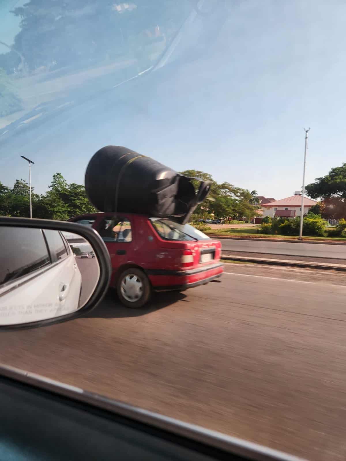
This was by far the hardest challenge in the set for me. It took me over 3 hours to solve it. 😅 The image shows the view from inside a moving car on a highway. I could see:
At least two lanes in our direction and an extra side lane
A red car in front carrying a large water container on the roof
A pedestrian bridge visible in the rear-view mirror
A series of tall poles with what looked like LED or solar lights
A low roadside building with some text on it, but too blurred to read
On the side mirror, I could read the classic warning text “Objects in mirror are closer than they appear,” which suggested an English-speaking country. I started by considering the United States and some territories like Puerto Rico or Hawaii, but things did not quite fit.
I tried using Bellingcat’s OpenStreetMap search tool to search for roads that matched certain criteria, for example:
Road type being motorway or primary
Presence of a pedestrian bridge
Nearby buildings of a certain height
This tool is very powerful, but I am still learning how to get the most out of it. My first attempts did not yield anything that matched the photo well. The big takeaway for me here was that I need more practice with this type of structured search.
After having looked around Puerto Rico and Hawaii, I decided to reconsider. The combination of tropical or subtropical vegetation, rooftop water tanks, solar street lights, the cars and the English language made me think more of this possibly being Africa.
So I shifted my focus to countries that:
Are mostly English-speaking
Drive on the right
Have at least some Google Street View coverage
Ghana and Nigeria quickly became my main candidates.
Next, I did a lot of manual scanning around Accra in Ghana and Lagos in Nigeria, looking for pedestrian bridges, but after a long search, I found nothing. I came close a few times in terms of “vibe,” but the details were always off. Either the bridge was wrong, the side lane was missing, or the lighting poles did not match.
While researching solar street lights in the region, I came across references to installations in Nigerian cities like Lagos and Abuja. I had already spent a lot of time in Lagos, so I decided to give Abuja more attention.
Around Abuja, I started to finally see elements that looked much closer to the challenge:
Pedestrian bridges with a similar design
Highways with multiple lanes and side lanes
Poles that looked like solar street lights
After a lot of zooming, scrolling, and bouncing between Street View and satellite imagery, I eventually found a stretch of highway where everything lined up.
Once I was confident I had the correct location, I used Street View and attached photos to inspect the building more closely. It turned out to be associated with the Daughters of Abraham Foundation, and photos from the location showed a hall named after a person whose name matched the blurry letters I could not read in the original challenge image.
Correct answer – Julie Useni
Foul Play – Watch out!
After the mental marathon of the previous challenge, this one felt almost relaxing.
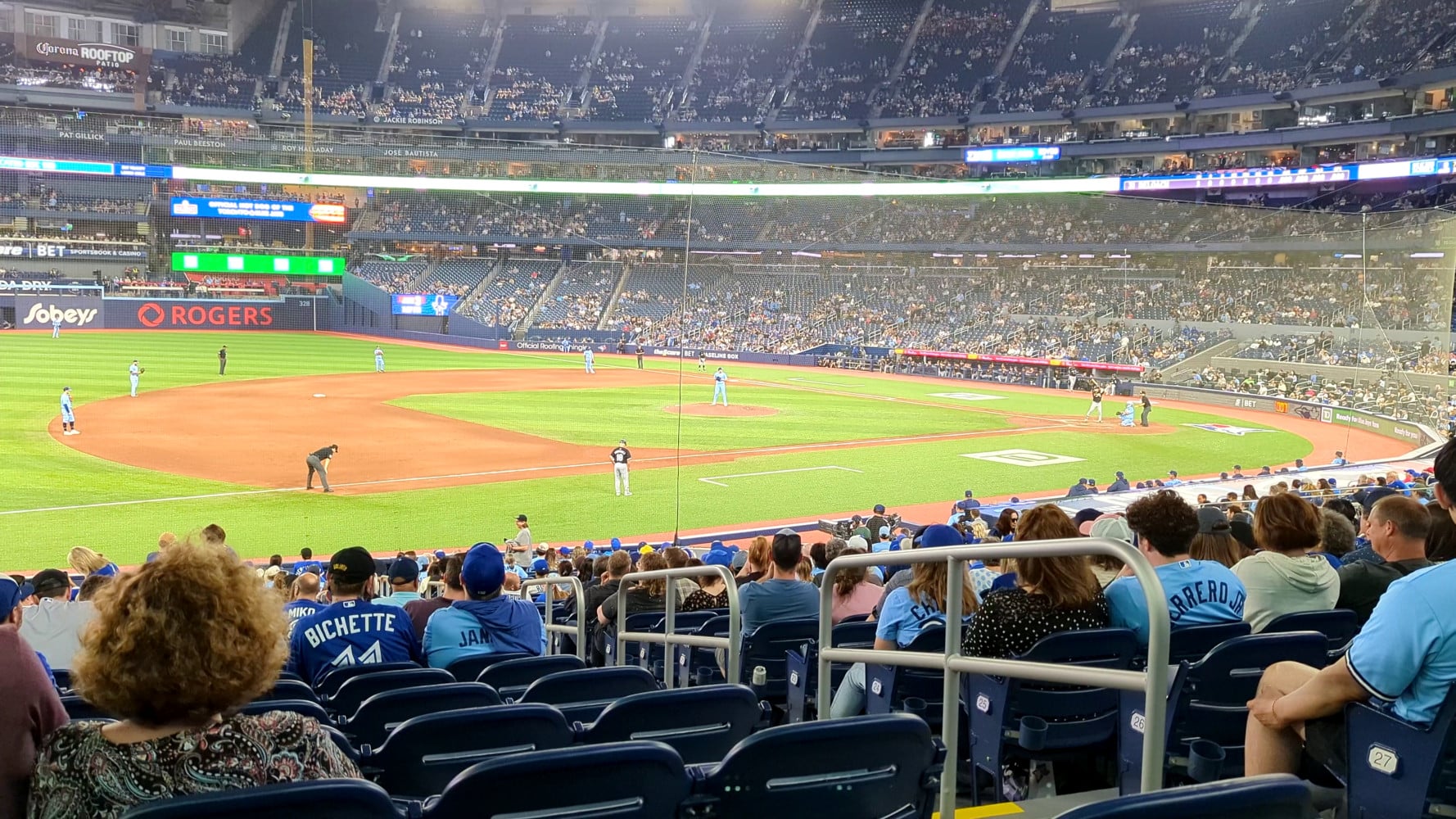
The challenge provided a short video clip from a baseball game where a foul ball flies into the stands, toward the camera. I know almost nothing about baseball, so I approached this purely as an OSINT problem.
The first step was to figure out where the game was taking place and which teams were playing. Around the stadium, I could see signs and branding with “Toronto” and “Blue Jays,” which made it clear that this was a Toronto Blue Jays home game.
The crucial clue, however, was on the scoreboard. If you pause the video at the right time, you can see text that looks like:
31 DELOACH
The quality is not amazing, but it is legible enough to search. Looking up “DeLoach baseball 31” quickly brings up Zach DeLoach of the Chicago White Sox. After some double-checking and making sure that the Toronto Blue Jays indeed played against the Chicago White Sox, I decided to submit his name as the answer.
Correct answer – Zach DeLoach
On The Metro – Where you headed?
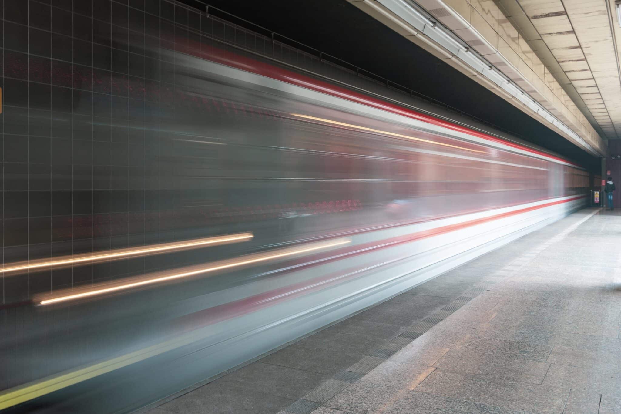
The final challenge takes us underground. The photo is very blurred because the train is moving quickly. From the image, I could make out:
A train with a light gray body with a red stripe along the top and around the middle
Brownish tiles on the station wall
Black and white markings near the platform edge
A yellow warning triangle sign with a little figure
Some natural light coming in from one side, which suggests that the station is partially above ground
My first instinct was to consider the London Underground because of the general feel of the warning signage. But London’s trains usually combine red, white, and blue in a different pattern, and the blurred metro color layout did not quite match. I also checked systems in New York and some Indian cities, but none of them fully fit either.
Eventually, while searching on Google for red and white metro trains, I found photos of the Prague Metro that looked very close to what I was seeing. That was enough for me to focus on Prague as the likely city. From there, the task became finding the exact station.
A Wikipedia list of Prague Metro stations with photos was helpful, but I could not immediately find a perfect match there. The station in the challenge looked quite plain compared to some of the more iconic designs.
Eventually, I found a YouTube channel that had recorded every metro station in Prague. That turned out to be invaluable. By going through the station videos and comparing wall tiles, barriers, and lighting, I finally found a station where everything aligned. That station was Hůrka on line B.
The challenge, however, asked for the destination station of the train. In the metro station video, a train at Hůrka clearly shows “Zličín” as its destination. That matches the line and direction that we need.
Correct answer – Zličín
Final thoughts
These “Urban Exploration” challenges were a great follow-up to the Maritime Mysteries set. They pushed me to:
Notice tiny visual details in noisy urban environments
Combine different types of clues, from license plates to graffiti tags
Use tools like Bellingcat’s OpenStreetMap search more intentionally
Stay patient during long stretches of trial and error, especially on the highway challenge
If you enjoy OSINT and geolocation puzzles, I highly recommend trying these Bellingcat challenges yourself before looking up the solutions. It is a very practical way to train your eye and your search skills on real-world imagery.
I will definitely keep tackling more of these and sharing my process along the way, so stay tuned!